


 |
How do
we get there? Plan A
From the South via Noosa, Double Island
Point and Rainbow Beach -
This is the best option, when the tides are right.
Take in the view along Teewah Beach and visit the Cooloola Coloured
Sands on your way to Fraser Island.
- The key question to be answered before taking
this route is "Can I safely get around the Mudlo Rocks just south of
Rainbow Beach township at low tide?" (The
Mudlo Rocks are marked on some maps as "Eight Mile Rocks".)
- One factor affecting your decision will be
the amount of sand on the beach. While there can be plenty of
sand for months, a cyclone or just a couple of days of heavy seas
can quickly remove sand and render the Mudlo rocks impassable. For the latest
beach conditions, check with the Ranger at the Rainbow Beach office of
the Queensland Parks and Wildlife Service on (07) 5486 3160.
- For safety, plan to be at Rainbow Beach as
close to low tide as possible and certainly no later than two hours
after low tide. The tides at Rainbow Beach are very close to
those at Noosa Heads. Look up Noosa Heads tides at the
Bureau of Meteorology
Oceanography web site. While you are there, also look up
Waddy Point tides. These will be useful for
driving on Fraser Island's eastern beach during your stay.
- Driving Instructions:
- - From Brisbane, drive north along the Bruce Highway (1) as far as
the Noosa turnoff at Cooroy (about 160km). The exit off the
highway is a left turn at the top of a double-lane uphill section.
- - (Unless you haven't seen Noosa Heads before, ignore the multiple
signs directing you off the highway towards Noosa between Forest
Glen and Eumundi.)
- - From Cooroy, drive east on the Cooroy-Noosa Road about 12km to
Tewantin.
- - At Tewantin, turn left at the Shell service station onto Moorindil
Road. There is now a roundabout at this turn. Continue about 2km to the Noosa River Ferry.
- - Noosa River Ferry price: $5.00 one way.
- - After crossing the river, follow the main track to the beach
(about 4km). Note the under-body car wash on your left; you
might need it on the way home.
- - Before driving onto the soft sand, stop and reduce the pressure in
your tyres.
- - Once on the beach, turn left and head north for about 60km towards
Double Island Point.
- - Check out the Cooloola coloured sands and the wreck of the Cherry
Venture.
- - 200m north of the Cherry Venture is the turn-off to the beach
north of Double Island Point. At this point, if the sand is
very hot, dry and soft, it may be necessary to switch to low range
in order to leave the beach.
- - This track is known as the "Leisha Track". (NOTE: For the past few months, this track
has been impassable due to severe erosion where it joins the northern beach near Double Island Point.
See Plan B on the
next page. - Mike, May 2007)
- - Once on the northern beach, turn left and head towards Rainbow
Beach township. Just before the township are the rocks which
should be no problem if you have done your homework and the tide and
sand level are as expected. If not, see Plan B on the
next page.
- - At Rainbow Beach township, you must leave the beach and drive for
a few kilometres on bitumen. Depending on your vehicle,
remember to leave 4-wheel drive and drive carefully because you will
have low pressure in your tyres.
- - Take the road up the hill out of the beachside car park.
- - At the "T" intersection, if you need a Fraser Island vehicle
permit, fuel or other supplies, turn left to go into Rainbow Beach.
Otherwise, turn right towards Inskip Point.
- - Drive north about 1km, and turn right at the roundabout.
- - Drive a further kilometre and turn right at the first sign which
says "Beach Access".
- - Once back on the beach, turn left and drive about 10km north to
Inskip Point.
- - Watch out for trees blocking the beach near the Inskip Point
campground. It may be necessary to leave the beach and use the
road for the last couple of hundred metres before the barge landing
point.
 - At Inskip Point, there may be up to three barges competing for
your business (typically $80 return for vehicle and passengers).
We recommend the Manta Ray, the green and gold barge. Phone
07 5486 8888 or 0418 872 599. No bookings are required; just be there before
5pm. - At Inskip Point, there may be up to three barges competing for
your business (typically $80 return for vehicle and passengers).
We recommend the Manta Ray, the green and gold barge. Phone
07 5486 8888 or 0418 872 599. No bookings are required; just be there before
5pm.- - On the southern tip of Fraser Island, you will have two choices:
* turn right and take the beach around Hook Point (about 3km)
or
* immediately leave the beach and take the inland road.
- - The beach is best if you are within two hours of low tide.
However at some points, the beach is very narrow and at other points
the sand can be suddenly very soft. Keep a constant slow
speed. Vehicles have been lost here when they travel too fast
while racing a rising tide.
- - The inland road should only really be used when conditions at Hook
Point are unsafe. This is an old mining road which hasn't been
maintained since sand mining ceased in the 70's. There are
craters bigger than some small vehicles and the rest of the surface
is bone-jarring corrugations, perfect for tossing salad. In
2002, the state government announced plans to upgrade this road, so
this situation may change.
- - From Hook Point to Eurong is 32km of the best beach driving in the
world. Note the reading on your odometer because there are few
landmarks . You might notice the road into Dilli Village at
about the 22km mark.
-
 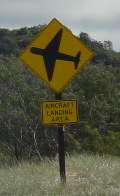 - The first indication that you are approaching Eurong will be the
yellow diamond road (beach?) sign indicating that aircraft land on the beach. - The first indication that you are approaching Eurong will be the
yellow diamond road (beach?) sign indicating that aircraft land on the beach.
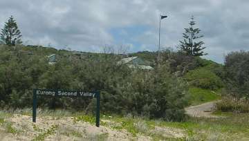
- 200m further on, you will see the Australian flag flying above
Fraser Island Beach Houses and a sign identifying "Second Valley".
This is Eliza St. Drive up off the beach and Reception will be
on your left. Welcome home.
- If, on the beach, you pass
Eurong Beach Resort, the visitor information centre or the police
station, you've gone too far. Go back a few hundred metres.
- See also, How to get there...
|
|