|
|
||
August, 2006 |
|
|
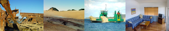
About Fraser IslandFraser Island lies just off the east coast of Australia. At 122 km long, it is the largest sand island in the world. Majestic remnants of tall rainforest growing on sand and half the world's perched freshwater dune lakes are found inland from the beach. The combination of shifting sand-dunes, tropical rainforests and lakes makes it an exceptional site. Fraser Island, situated adjacent to Hervey Bay, Queensland is the largest sand island in the world. Fraser Island, named after shipwreck victim Eliza Fraser this World Heritage listed sub tropical island has a truly amazing array of natural wonders including beautiful rainforests, pristine lakes, endless surf beaches, immense sand blows, cliffs of coloured sands, crystal clear streams and vast stretches of mangroves. The Island is 125km long and over 160,000 hectares in area. It was formed during the ice age when the prevailing winds transported the vast quantities of sand from New South Wales and deposited it along the coast of Queensland forming the island as we know it today. In this fragile eco system the rainforest consists of huge satinay and brush box, kauri pines, piccabeen palms and the rare angiopteris fern which is one of the largest ferns in the world. All this growing in pure sand ! There are some wonderful walking tracks through these areas to enable visitors to appreciate the unique beauty of the island. There are a number of lakes on the island each with their own individual character - from lakes stained red with tannin to others with pure white sand and crystal clear water. Swimming in these lakes is memorable experience. Fraser is also home to over 200 species of birds along with a variety of mammals, wallabies, snakes, possums, turtles and flying foxes. Now listed as a World Heritage site, Fraser joins the ranks of the Great Barrier Reef, Uluru and Kakadu National Parks as being of universal significance as the largest coastal dune system and sand island in the world and for its special environments. As a precious part of Queensland's natural and cultural heritage, it is protected for all to appreciate, enjoy and respect. PRISTINE LAKES AND CRYSTAL CREEKS If sand is the key to how Fraser Island was formed, then water has been the reason it has become so special. The combination of environments, particularly the rainforests, have established through Fraser's wealth of freshwater sources. CREEKS Crystal clear creeks and streams flow through the cool, shady forests and out into the sheltered waters of Hervey Bay on the western side of the island. Along the ocean shore, hundreds of streams punctuate the smooth, sandy beach. But of all the creeks and streams on Fraser, two stand out as exceptional. Wanggoolba Creek at Central Station flows silently over white sand along the floor of a thick rainforest. A major port of call for visitors, Wanggoolba's creekside walkways pass the angiopteris ferns, an ancient species boasting the largest single fern fronds in the world. Eli Creek on the eastern side of the island, is the largest of the freshwater streams flowing into the ocean. Eli is popular with visitors and walkways allow you to appreciate its beauty. Stop for a while and spot the kingfishers as they dart amongst the pandanus and casuarinas. LAKES It would be hard to imagine lakes clearer than those on Fraser Island. The water is so pure that the 40 or so lakes support relatively little life. There are three types of lakes on Fraser, window, barrage and perched lakes. Window lakes occur when the ground drops below the water table. The fine white sandy base acts as filters, giving the water its clarity. There are several window lakes including Yankee Jack, Ocean lake and Lake Wabby. Lake Wabby is also termed a barrage lake, which is formed by the damming action of a sandblow blocking the waters on a natural spring. Wabby is relatively close to the ocean side of the island and unlike the other lakes it supports several varieties of fish. It is also a good example of the sandblow phenomena, gradually encroaching on the deep green waters of Wabby as the sandblow makes its gradual progress westward across the island. Swimmers in the lake should not run and dive off the sandblow - the water is very shallow close to the edge of the lake. Perched lakes occur above the water table. Saucer-shaped depressions with a hard, impervious base of organic matter and sand, form a catchment for the rain eventually creating the lake. The peat-like base generally stains the water the colour of tea. In the northern half of the island, Lake Bowarrady is the highest of the perched lakes being some 120 metres above sea level. In the southern part of the island there is Lake Birrabeen and the popular Lake McKenzie. Lake Boomajin approximately 190 hectares in area is the world's largest perched dune lake. Each of the lakes has its own particular character. Mysterious, moody and beautiful, they are excellent subjects for photography, great places to see birds, other fauna and flora and a welcome oasis for the hot Summer days. Scenic 4WD circuits and walking tracks in the southern half of the island take in some of the largest of the lakes including McKenzie, Birrabeen, Benaroon and Boomajin, There is a walking track to Lake Wabby from the beach. ENVIRONMENTAL CODE To maintain the natural beauty of the lakes on the island, please ensure you observe the following guidelines: Do not pollute waterways with soaps or detergents. Power boats and vehicles are not permitted in the lakes. Do not feed dingoes or other native annals. Boil all water taken from natural sources on the island. Respect the peace of the other visitors. Take only photos. Leave only footprints. NATIONAL PARKS, FORESTS & SAND Fraser Island is part of the Great Sandy Region, the section of coastline stretching from the north shore of the Noosa River below Lake Cooroibah and Cooloola National Park, to Sandy Cape at the northern tip of Fraser. About half of Fraser Island is currently national park. The Great Sandy National Park occupies the northern half of the island. The southern half is almost entirely crown land and state forests, proposed for national park, subject to resolution of Aboriginal land interests. WORLD HERITAGE LISTING Fraser Island attained its World Heritage Listing in December 1992 in recognition of the island's exceptional sand dune systems, its rainforests on sand and its pristine freshwater lakes. Fraser Island is the tenth World Heritage listed site in Australia, joining the ranks of the Great Barrier Reef, the Wet Tropics of Queensland, Uluru National Park (formerly Ayers Rock) and Lord Howe Island. The listing recognises Fraser's combination of environments as having outstanding universal value and its protection for future generations as a global responsibility. World Heritage Listings began almost twenty years ago under the auspices of the United Nations with establishment of the World Heritage Convention, to which Australia is a signatory. 127 countries are party to the convention, established to identify, protect and preserve properties which qualify for World Heritage Listing. The two criteria against which Fraser Island was judged eligible for listing as a natural site were as follows: if it was an outstanding example representing significant on-going geological processes, biological evolution and man's interaction with the natural environment; and if it has superlative natural phenomena, formations or features. While the World Heritage Committee does not have the power to dictate how the listed site is managed, signatories to the convention, such as Australia, have an obligation to observe the ethic of the listing. The purpose of World Heritage Listing is to recognize Fraser Island as having unique and precious natural environments of universal value that should be protected. Fraser Island has emerged from a century of exploitation of its rich resources - timber, sand minerals and fish. Logging and sand mining have ceased after many years of campaigning by environmental groups. The challenge for the island in the future will be in managing the growth in tourism. A detailed management plan has been developed by the Fraser Implementation Unit, part of the Queensland Department of Environment and Heritage, for Fraser Island and the Great Sandy Region which sets a strategy to the year 2010. The responsibility of protecting Fraser for future generations, however, belongs to all visitors in respecting the island's environments. The unique qualities of Fraser Island make it a destination you must see! PHYSICAL FEATURES The region largely reflects Quaternary geomorphological processes along a fluctuating coastline, influenced by earlier geological history and the continental shelf. Fraser Island, 122km long and 5-25km wide is claimed to be the biggest sand island in the world. The sandmass is the major geological element, with the sand extending 30-60m below present sea level. The area represents a complete sequence of sand dunes, extending from the Holocene period (less than 10,000 BP) to before the last Pleistocene interglacial period (120,000-140,000 BP). The sand derives from granites, sandstones and metamorphic rocks in river catchments to the south and from the seafloor. Fossiliferous Lower Cretaceous marine charts are exposed in the intertidal zone on the west of Fraser Island (DASET, 1991). The hydrology of the sandmasses is of considerable interest and importance due to the unique strata and the almost unaltered catchments of the region. Notable features are the sandmass aquifers and the dune lakes. The aquifers consist of an extensive regional freshwater 'lens' within each porous sandmass and perched aquifers associated with more or less impervious organically bound sands. Groundwater on Fraser Island is stored in massive reserves (estimated to be around 10-20 million megalitres) within the sandmass, of which almost 6 million megalitres is above sea level. A further 400,000 megalitres may be retained in the perched aquifers. Water may be stored for up to 70-100 years. The 40 perched, window and barrage dune lakes are unusual in the world, due to their number, size, elevation, depth and oligotrophic waters. The perched lakes on the island comprise more than half the known perched lakes in the world. Some of the perched lakes, formed in wind scoured depressions that later become impermeable due to collection of organic matter, are estimated to be up to 300,000 years old, and contain in their organic sediments a continuous record of changes to the island's hydrology and vegetation through Quaternary glacial and interglacial cycles. Window lakes form in low elevation dune depressions that intersect the Island's regional water table. Barrage lake are thought to originate from groundwater springs, dammed by a wall of landward migrating sand (DASET, 1991; Sinclair and Morrison, 1990). CLIMATE Conditions are maritime subtropical with mean annual temperatures ranging from 14.1� C minimum to 28.8� C maximum. Rainfall is high, reaching 1,800mm on the highest dunes in the centre of Fraser Island (DASET, 1991; Sinclair and Morrison, 1990). VEGETATION Comprises seven main vegetation types: closed forest including rain forest and tall eucalypt forest dominated by satinay and brushwood; blackbutt forest; scribbly gum and wallum banksia communities; communities of wet sites often dominated by Melaleuca spp.; coastal communities; Callitris forest and woodlands; and mangrove and saltmarsh (Queensland Government, 1990a). There is clear zonation and succession of plant communities according to salinity, water table, age and nutrient status of dune sands, exposure and frequency of fires, creating a generally east-west sequence of vegetation (Sinclair and Morrison, 1990). The rain forest is characterised by upper strata species such as piccabeen palm Archontophoenix cunninghamiana, hoop pine Araucaria cunninghamii, kauri pine Agathis robusta and carrol Backhousia myrtifolia. This community covers about 3,260ha of the island with approximately 25% currently represented in the national park. The tall eucalypt forests, dominated by pure stands of blackbutt Eucalyptus pilularis, occur mainly on the high dunes adjoining the rain forests. The low sclerophyll forest, behind the foredunes stretching back to the taller eucalypt forest, is dominated by scribbly gum Eucalyptus signata (Sinclair and Morrison, 1990). The boundary of the region is given as 500m below high water mark, in order to include important areas of beaches, wetlands and mangroves, and part of the extensive seagrass beds in the Great Sandy Strait, which extend to more than 12,500ha (DASET, 1991; Sinclair and Morrison, 1990; A. Turner, pers.comm., 1992). The region is particularly important for relict populations of fern species, with around 50 species (including varieties) found on Fraser Island. A species list is given in Twyford (n.d.). The island is noted for its low number and abundance of introduced species, presence of false water-rat Xeromys myoides (VU) (Twyford and Hobson, 1996) and high genetic purity of dingo Canis lupus dingo relative to other areas in eastern Australia CULTURAL HERITAGE Aboriginal people are thought to have first occupied the region about 40,000 years ago. The earliest date for the occupation of Fraser Island is currently 1,500-2,000 years, although it is possible that further archaeological work may reveal evidence of earlier occupation. Four main groups of Aborigines dominated the Great Sandy region before the arrival of Europeans. Visible remains of Aboriginal settlement include middens, canoe and gunyah trees, and a few other markings such as scars where bees nests have been removed. Although examination of the archaeological potential of the region has been restricted, a number of sites have been located, particularly adjacent to the eastern shore. Over 200 shell middens have been found on Fraser Island. CONSERVATION VALUE Fraser Island is the largest sand island in the world. The combination of rain forests growing on tall sand dunes is believed to be a globally unique ecosystem. The array of dune lakes is exceptional in terms of number, diversity and age and the evidence they provide of dynamic development (DASET, 1991).
Things to see and do on your holiday.
Things you should know about planning a holiday in a wilderness area.
This site was last updated 12-Aug-2006 |
|||||||||||||||||||||||||||||||||||||||